 D&T Prominas | Coordinate System Manager: Conversion of Complete Coordinates (UTM E, N, Z and Geographic)
Did you know that the MinePlan Do you have a complete coordinate conversion tool so that your data is always correctly georeferenced? It is about Coordinate System Manager, present in the menu Filet of MP3D.
With this tool, you can create DATUM UTM conversions to import and export data. The field External Coordinate System represents the DATUM used in the data to be imported or exported (external in another datum), while the field Project Coordinate System is the system used in your project of the MinePlan, which is the base DATUM.
As all 3D design software uses UTM coordinates to represent the Cartesian plane and thereby reduce internal processing, the use of geographic coordinates has always been hidden behind indirect and detailed conversions. But now using the Coordinate System Manager direct export in geographic coordinates is possible, enabling numerous applications, such as direct export in KML.
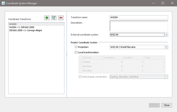
Figure 1: Coordinate System Manager interface
In this way, the Coordinate System Manager performs conversions of projected DATUMs, with UTM coordinates, and also of geographic coordinates, represented in latitude and longitude.
It is worth remembering that the actual conversions are in 3D. While in traditional 2D georeferencing software, the most common is to do the horizontal transformation, ignoring the elevation, the Coordinate System Manager won't let you forget, already carrying out the complete transformation of your coordinates, including the elevation.
the section Local Transformation receives information about adjustments to projects' local DATUMs. Translation, data rotation and scale can be adjusted to improve conversion if there are differences in units used, for example.
As there are many options for coordinate systems, it is possible to refine your search based on keywords, or using a filter, which allows you to view only projected or geographic systems, according to your needs.
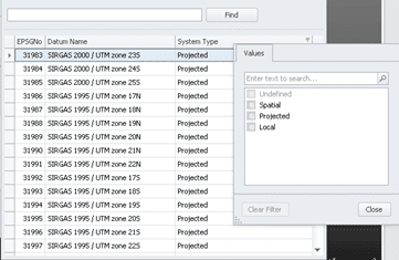
Figure 2: Search and filters.
The conversion of DATUMs can be applied in various ways of importing and exporting data, such as files *.xyz, *.srg, *.csv, *.kml, between others. To perform the transformation, simply select the desired option.
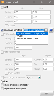
Figure 3: Using the conversion to export data.
So, did you like the tip? For more information about the Coordinate System Manager, contact our team and we will be happy to serve you!
To the next!!!
Team Prominas Mining