
Meet Hexagon MinePlan GeoLogic: Implicit geological modeling in MinePlan. Did you know that the MinePlan package has a powerful implicit geological modeling module? In today's Tips & Tricks, we'll talk about it: GeoLogic! GeoLogic is a MinePlan package software capable of creating surfaces and solids, generating a robust and representative three-dimensional model of the geology of a given region. The program uses Radial Basis Functions (RBF) algorithms to model geological bodies from drilling data, trench samples or mining fronts. The results show closed solids, with natural contours and statistical reliability (Figure 1). Figure 1: Differences between explicit (left) and implicit (right) modeling. GeoLogic can be opened under MP3D's Geo Tools menu, presenting a simple and intuitive interface. It allows you to generate events…
blog

Are you aware of the news? Registration is open for the NEW edition of our immersion and technical training program, Prominas University. Get ready for a dive into the world of Geological Modeling! It is with great satisfaction that we announce the next edition of Prominas University – PUGeo23-1, an unmissable event for geology students and professionals. This time, our focus will be on the fascinating universe of Geological Modeling, an essential discipline in our area of work. We want to provide an enriching and practical experience, where you can deepen your knowledge, improve your skills and expand your network of contacts in this dynamic area. If you are a student or newly graduated professional passionate about Geology, this is the perfect opportunity to update yourself and connect with other colleagues in the field, and all this for free! Program Start: 26/06/2023 Duration 2 weeks…

MPReserves – Covering between topographies: Practicality to carry out the cubing between two topographies. Did you know that MinePlan has a tool that calculates reserves between two surfaces? With the MPReserves tool, which has its own menu, the user can select two topographies so that the calculation of reserves is carried out using information from the Block Model. Accessing the “Setup Reserves” option, located in the Reserves menu, navigate to the Surface Cuts tab and select the topographies of interest using the Add Surface Cut(s) option. Afterwards, you must specify the position of the topographies in the “Position” column. In addition, in “Surface Name”, the user can change the name of the surfaces, thus customizing the visualization of the results. Figure 1: Surface Cuts tab – MPReserves. Using the Calculate Reserves option, the tool will measure the topographies, generating a dynamic table…

MPSO Block Schedule Coding: Encode the result of Mining Sequencing in the block model. Did you know that MinePlan Schedule Optimizer (MPSO) has an option that allows the user to easily stamp results into the Block Model? The Block Schedule Coding option, located in the Utilities menu, makes it possible to stamp Block Model items with the sequenced periods and destinations to which the materials were sent. After accessing the option, you can, in a simple way, configure the Destinations tab, through the Code column, inserting the desired numeric code that each destination will represent in the Block Model. In the Destination Item option, you must specify the model item into which the values will be encoded. Figure 1: Destinations tab in Block Schedule Coding – MPSO. In the Periods tab, you can specify in the Period Item column the variable of…
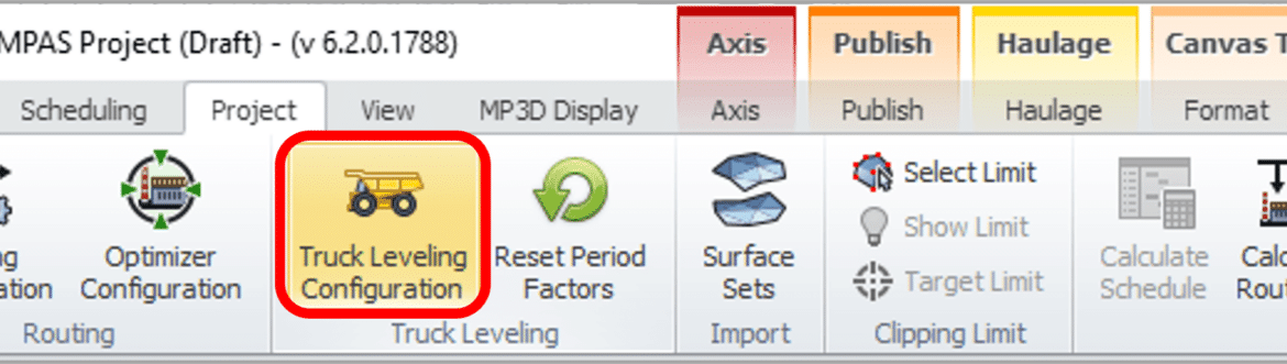
MinePlan Activity Scheduler – Truck Leveling: Practicality in leveling the number of trucks. Did you know that MinePlan Activity Scheduler has a tool that automatically levels the number of transport equipment when distributing material? Short-term planning is one of the main channels of communication between planning and mine operations. The Truck Leveling Tool allows the user to optimize material movement based on the schedule and limit truck over-utilization, automatically reducing excavator productivity. This helps to eliminate equipment overuse and create an effective schedule in a short amount of time, allowing you to analyze and adjust the number of equipment in the fleet to ensure that the target is achieved. To use this tool, click on the Truck Leveling Configuration option located in the Project panel. The tool…

Point Editor: Versatility and precision in creating and editing points. Did you know that MinePlan 3D (MP3D) has a tool that allows you to create and edit points using specific coordinates, relative distance and/or vectors? The Point Editor tool allows you to create/edit points from input of desired coordinates. It works in conjunction with other editing tools, and allows you to create and move points, independent or associated with a line or polygon. The Point Editor is accessed through the Utilities menu. After opening the tool, you should start some editing operation with another tool, such as Create Point, Move Point, Create Polygon or Create Polyline, and the Point Editor will act as an auxiliary tool. For example, when creating a line, you can add the points of that line through the Point Editor. It is possible to add points in a…
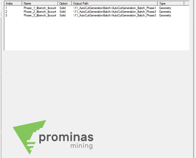
Auto Cut Generation Batch: Agility in the generation of cuts. Did you know that MinePlan now has a feature that allows the generation of cuts for several objects in sequence? Located in the Utilities menu, the Auto Cut Generation tool now has a new tab called Batch, allowing the user to queue up the solids to be cut. To form this queue, you must first configure the parameters on the Options tabs (selection of solids, polygons or lines, definition of limits, etc.) and Naming (definition of the names of the Elements and associated Material). Then, on the Batch tab, click Add and select the object that will receive this result. By repeating this process for each solid, the queue will be built. With the queue already built, you can observe some information about the cuts: Index, listing the order that…

Set Global Color by Range: Simplicity and personality for viewing groups of data in MinePlan. Did you know that MinePlan 3D (MP3D) has a feature that allows you to color objects using a color scale? This functionality of MinePlan allows you to color several objects at once, with pre-defined or user-created color scales, thus improving the visualization of your data for use in presentations and reports. To perform this configuration, you need a group of objects and a color scale. Then, select all the objects you want to color in the Data Manager menu, clicking and dragging them, or using “Ctrl” + Left Mouse Button to individually select the objects. With the objects selected, click the Set Global Color by Range button, located in the Object Properties window,…

Query Minimum Distance Between Elements: Efficiency and ease to measure distances between different elements in MinePlan. Did you know that MinePlan 3D (MP3D) has a feature that allows you to quickly calculate the distance between different elements? Located in the Query Menu, the Minimum Distance Between Elements tool has the function of reporting the minimum distance between elements, creating a virtual element to represent this distance in space. It is a very dynamic tool, requiring only the selection of the types of elements of interest. For example, measuring the minimum distance between a point and a line, or, between a plane and a surface. Possible selection elements for the tool are: Points, Vector, Line Segment, Polyline, Plane, Face and/or Surface. The start and end element are set, and the Snap is activated automatically according to the element, to…
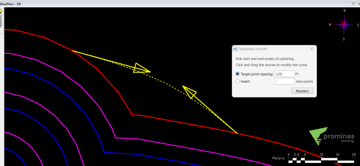
Smooth Substring: Practicality in smoothing line segments and polygons. Did you know that MinePlan has a very practical tool for smoothing lines and polygons? With the Smooth Substring tool, located in the Polyline – Substring menu, it is possible to dynamically smooth the shape of lines and polygons in order to obtain a new format. When starting the tool, you must define how new points will be created that will change the geometry of the line/polygon: Figure 01: Polyline – Smooth Substring. Target point spacing: Specify a distance that represents the interval between the points that will be created between the starting and ending points of the chosen segment. Insert new points: Define the new number of points that will be created between the starting and ending points of the chosen segment. Once the methodology is chosen, just specify the segment…